
Courtesy of the MABRC
Starting your own research (Presentation slides are at bottom of the article)
The most common question MABRC members get posed to them is “How do I find my own research area?”, and after conducting numerous presentations at Bigfoot conferences on how to find and develop a research area, we decided to put it in print for the Guidelines Manual.
To start with, a researcher should check out sighting reports for their immediate area, starting with BFRO, GCBRO, Bigfoot Encounters, MABRC and other Bigfoot Research groups that obtain reports in your area.
Look for Class “A” type, or actual sightings that have occurred in the reports, and compile a list of those sightings including the location, this will be important later.
Go to Microsoft Research Maps at http://msrmaps.com and zoom into your area. This site allows you to switch between aerial photos and topographical maps. This allows you to view the area from different perspectives.
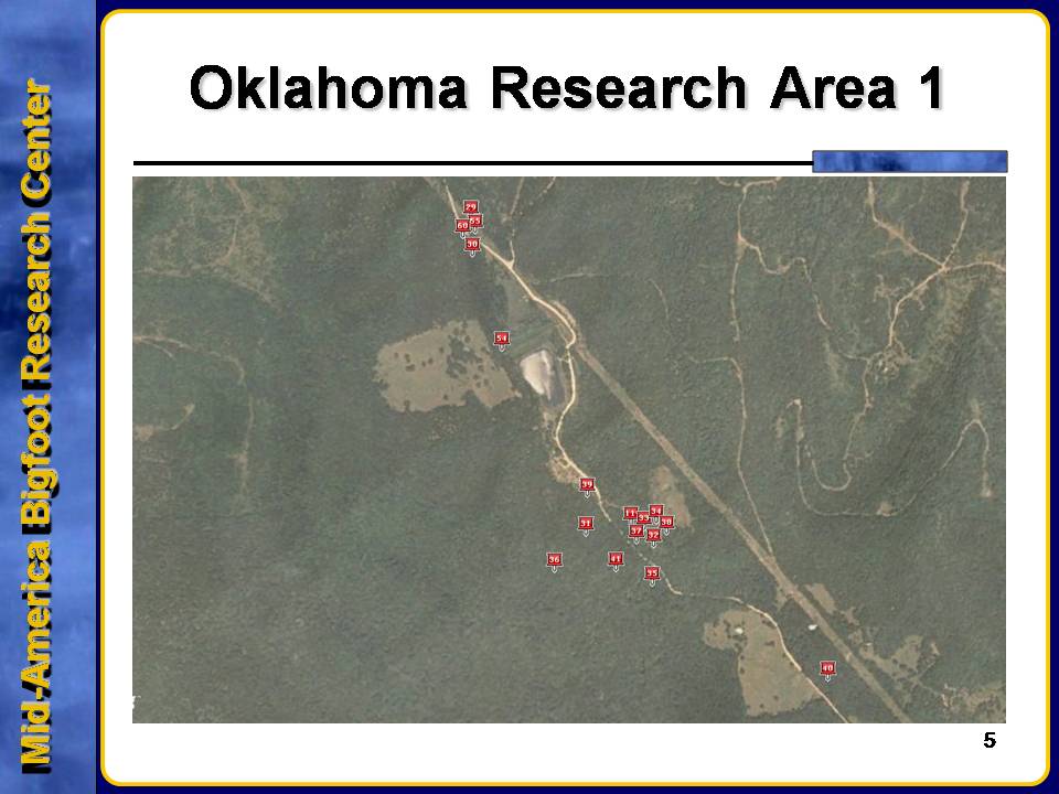
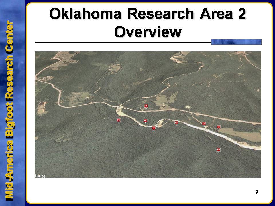
You can also go to http://www.google.com/earth and use this to plot the sightings you look up onto a satellite map to get a better overview of where they are in relation to one another.
You also need to look for prominent features for an area, like water sources, food sources, natural cover and concealment, and natural or man-made avenues to travel on.
Watersheds and lakes support large numbers of various wildlife and a watershed can support a Bigfoot troop with food and water year round. Interconnecting waterways should also be examined to see where they may give a travel avenue between locations. In many of the MABRC research areas, certain creeks connect the areas together, although they may be many miles apart.
Food sources are important too, local farms raising pigs, cattle, chickens and other agricultural food stuffs give Bigfoot an opportunity to food. Large deer populations, wild edible plants, fish, mussels and turtles in the area will sustain a sizable Bigfoot troop. Garbage dumps/bins and slaughterhouses should also be viewed as possible food sources.
Three main research areas of the MABRC are within 5 miles of a major landfill, with multiple sightings within that 5 mile radius.Cover and concealment seems to be always favored by Bigfoot and this includes box valleys, bluffs with overhangs, sheltered valleys, heavy foliage and abandoned rock quarries. Look for places that a Bigfoot could hunker down during bad weather and exploit these areas during those times.
Avenues to travel on include railroad lines, pipelines, electric/utility right of ways, old roadbeds, old trails and dikes. While it isn’t proven that Bigfoot use these to travel on, the MABRC has conducted a study that shows many reports happen within several miles of an avenue of travel.
Talking to locals may also benefit finding a research area, hand out brochures, business cards or other advertisements. Talk to area residents, listen to talk in restaurants, let folks know you are interested in their stories. Talking to local law enforcement and newspaper reporters can also gain you access to strange reports that might be disregarded if they didn’t know about you and your willingness to investigate.
Recon an area by driving around it, walk through it (make sure you have the landowner’s permission first though), observe and note, and even sit and listen with a parabolic listening device, you may be surprised what you hear.
Document everything you find out about an area, photograph everything, it may not seem important now, but it may later. GPS everywhere you go, mark it on a map of the area for later reference.
While these tips may not benefit everyone, as each person will obviously find the best ways to locate their own research area, it still gives individual researchers a basic sense of how to locate their own research areas.
While there is no set procedure for scouting out and finding your own research area, the MABRC can give pointers to individual researchers on how to locate potential “Hot Beds” of activity.
Topographical and Aerial Photos
One of the first steps is to check out topographical maps of potential areas you want to check out, you can access many online through http://www.bing.com/maps or the U.S. Geological Survey website at http://store.usgs.gov and learn everything you can about reading these types of maps.
Prominent features that you want to look out for are water sources, food sources, natural cover and concealment, natural or man-made avenues to travel on.
Watersheds and lakes
Watersheds and lakes are also important to take note of. For example, Oklahoma has numerous watersheds that support large numbers of wildlife, and it’s surmised that each watershed can support a Bigfoot troop. With interconnecting waterways, these can provide a safe avenue of travel for a troop, as well as being dependable water sources.
During droughts, troops are more likely to stay close to water sources even at the risk of detection.
Food Sources
Food sources can be local farms with large numbers of livestock (i.e. pigs, cattle, chickens, etc.) or even large plots of agricultural items. Large deer populations are also a draw for Bigfoot, along with wild edible plants. For the types of edible plants in your area, please refer to Project Foodbasket on the MABRC Forums.
Water sources can also have an abundance in fish, mussels and turtles.
Garbage dumps and bins also seem to attract Bigfoot as they rummage through them looking for food. At Honobia Oklahoma, the town dumpsters are on the south side of town, and multiple sightings have occurred where the Bigfoot were found to be going through them.
Slaughterhouses are another good place to locate, as many rural slaughterhouses don’t always follow EPA guidelines and sometimes dump the remains of slaughtered animals in dump pits out of sight. This occurred in the mid-90s with the white Bigfoot being caught going through the dump pit on numerous occasions.
Cover and Concealment
Look for areas that Bigfoot can use to conceal themselves and to cover their movements. Such things as box valleys, bluffs with overhangs, sheltered valleys, heavy foliage and even abandoned rock quarries can provide a troop with numerous options.
Avenues to travel on
There is a lot of debate in the Bigfoot community about Bigfoot using easy avenues to travel on. In the MABRC, we concentrate our efforts near railroad lines, pipelines, electric/utility right of ways, old roadbeds, old trails and even dikes. While the likelihood of Bigfoot using these avenues may be unlikely, the possibility exists that they could use them as navigational aids to travel long distances. In the research areas in Mid-Eastern Oklahoma, the majority of Class “A” sightings have occurred within 3 miles of a major electric right of way that cuts through the area. Researchers in the area have worked on this theory for well over 6 years now, and their belief in this appears to be well-founded with the number of encounters and activity experienced not only by themselves, but other MABRC and Independent Researchers who have visited those areas.
Sighting Reports
Going through the various sighting report databases, whether it be the MABRC OSSIE Database, the BFRO, GCBRO, Oregon Bigfoot, etc., will also bring about a better picture of an area. Go back 5 years on sighting reports, as this would allow you to note trends for the 5 years previous to your research in the area. Only use reports that an actual sighting occurred, and note all the details that may be critical, such as direction traveling, location, time of day or night, weather, month, and so on, to give yourself a better understanding of the times and directions that the Bigfoot are using this area.
Places to look for sighting reports
The MABRC maintains a large database compiled of reports from every Bigfoot website that can be found, including the now defunct International Bigfoot Society. Other locations to look are:
http://www.bfro.nethttp://www.gcbro.comhttp://www.texasbigfoot.org (OK, TX, LA and AR only)http://www.texlaresearch.com (TX, LA only)http://www.oregonbigfoot.comhttp://www.bigfootencounters.com
Talk to the locals
Talking to the locals can bring mixed results, but you never know until you begin talking to someone if they have a Bigfoot sighting or know of someone that has. Activity that they were unsure of could also be indications of Bigfoot in the area.
Hand out brochures (the MABRC has one on the forum for MABRC Members to use), business cards (the template is on the forum for MABRC Members to use) and other advertisement means.
Talk to the residents, be courteous and mannerly, do not talk out of turn, do not interrupt and do not lead the conversation, let them tell you in their own words. After they are finished, ask your questions then.
Let folks know you are interested in their stories, do not make the mistake a lot of researchers make by acting like you know everything about Bigfoot.
Talking to local law enforcement and newspaper reporters may bring some serious stares at you, but if they know you are involved in Bigfoot research and an incident in your area happens related to a possible Bigfoot, they hopefully will remember you and give you a call for help in understanding the situation.
Recon an area
It’s now time to recon the area, and at first it will be easier to drive around the area on the local roads, noting the terrain first hand and also any features to watch for in the future. Also take note of buildings, lights and other man-made articles that could divert the path of a troop.After you become familiar with the area, do a walk through the area in the daylight (make sure you have the land owner’s permission first) and get a really good feel for the area. Also look for potential markers that you make encounter during the daylight hours. It’s also a good idea to have a digital voice recorder going so that if any vocalizations occur, you will record them. A camera to take pictures with is also a must.
Always observe and note, remember, there is no such thing as having too much documentation.With all your documentation and onsite visit, you will more than likely locate several good spots to come back with a parabolic and set up a listening post at night (only when you are familiar enough with the area to do so) and listen for signs of activity to occur.
Documentation
Documenting your information is important for review later and for submission of your evidence. Write down everything you find out about an area. Photograph everything, it may not seem important now, but it may later on. Using a GPS to mark important places and tracks where you’ve been will allow you to keep track on a map for later reference and for a return to those locations.


No comments:
Post a Comment